
Rein Orchid in Little Green Valley meadow
Mountain Hiking Club
Contact: Karla Kellems 760-405-4311 <karlakellems@gmail.com>.
Before beginning a hike, take into account your available time, knowledge of the area, necessary equipment (especially water), and weather conditions. Remember you are at 7000 feet, so don’t overdo it at this altitude. Leave word with a friend and avoid hiking alone.
Green Mountain is the highest peak in our immediate area. It is on the eastern edge of the southern ridge above Green Valley Lake. From atop this southern ridge (sometimes called Little Green Valley Ridge), one has excellent views of Butler Peak and beyond.
2N19 (5 miles, difficult):
One way to get to this ridge is to begin at Green Valley Campground. 2N19 rapidly climbs out of the campground to the top of the ridge. By walking along the ridge towards the EAST, the trail begins to slowly descend towards Green Valley Road. From here you can return the way you came, or you can shuttle back to the campground. Numerous unnamed routes of all levels of difficulty are available in either direction from the top of this southern ridge .

Torrey’s Lotus
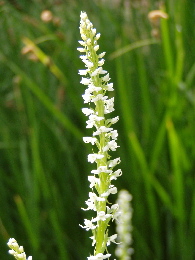
Along the top of the ridge, if you chose to hike towards the WEST instead, you would end up in the natural alpine meadow known as Little Green Valley. It used to be a YMCA camp but just recently the Forest Service restored it to its original condition. The meadow is a very unique environment and you will see many interesting wildflowers growing here in the summer months. The largest and most numerous are the corn lilies. If you do a little exploring, you may also find rein orchids growing in a riparian area and also Torrey’s lotus. [Please remember that picking wildflowers is forbidden by law.]
Little Green Valley Trail 2W10 (1.5 miles, difficult):
Another way to get to this alpine meadow is to take 2W10. This trail begins on the north side of Highway 18 between the two entrances to Snow Valley Ski area. The trail climbs steeply to the north until you reach the meadow (“Little Green Valley”) at FS Road 2N19. This trail provides you with outstanding views of Snow Valley and Slide Peak.
Though not marked on any maps, there is a trail on the north ridge of Green Valley Lake as well. It parallels the street called Holcomb Creek Dr., just staying to the north of it. You can start this trail from the Old Crab Flats Rd. (2N86) which continues north from the street called Wild Cherry. After walking only 50 yards, and before the road starts to descend, turnEAST and follow the ridge trail all the way to where it intersects with the Fawnskin Road (2N13). You will soon be at the northern end of the Green Valley Campground. If you continue down 2N13 for 10 more miles, you will end up in Fawnskin at the north shore of Big Bear Lake. This road is also known as “Snow Slide” and used to be a toll road; it was the original and only way to get to Big Bear before Highway 18 was built.

Corn Lily in Little Green Valley meadow
If you stay heading north and northwest on 2N86, you will soon intersect with 2N54 . This is another lovely trail that will take you east and intersect with the Fawnskin Road (2N13).
There are many other trails not marked on hiking maps in and around Green Valley Lake. Some of the upper ones offer spectacular views of the San Gabriels to the west and Lake Arrowhead. Some of the lower ones connect to the Crab Flats Road (3N16) and are fun to explore when the weather is nice. 3N16 is heavily used by off-roaders and can get quite dusty and noisy, so it is recommended to explore the trails that lead away from the Crab Flats Road.

Click for larger picture